Technological characterization of marabou-covered areas for energy purposes using GIS
Article Sidebar
Main Article Content
Abstract
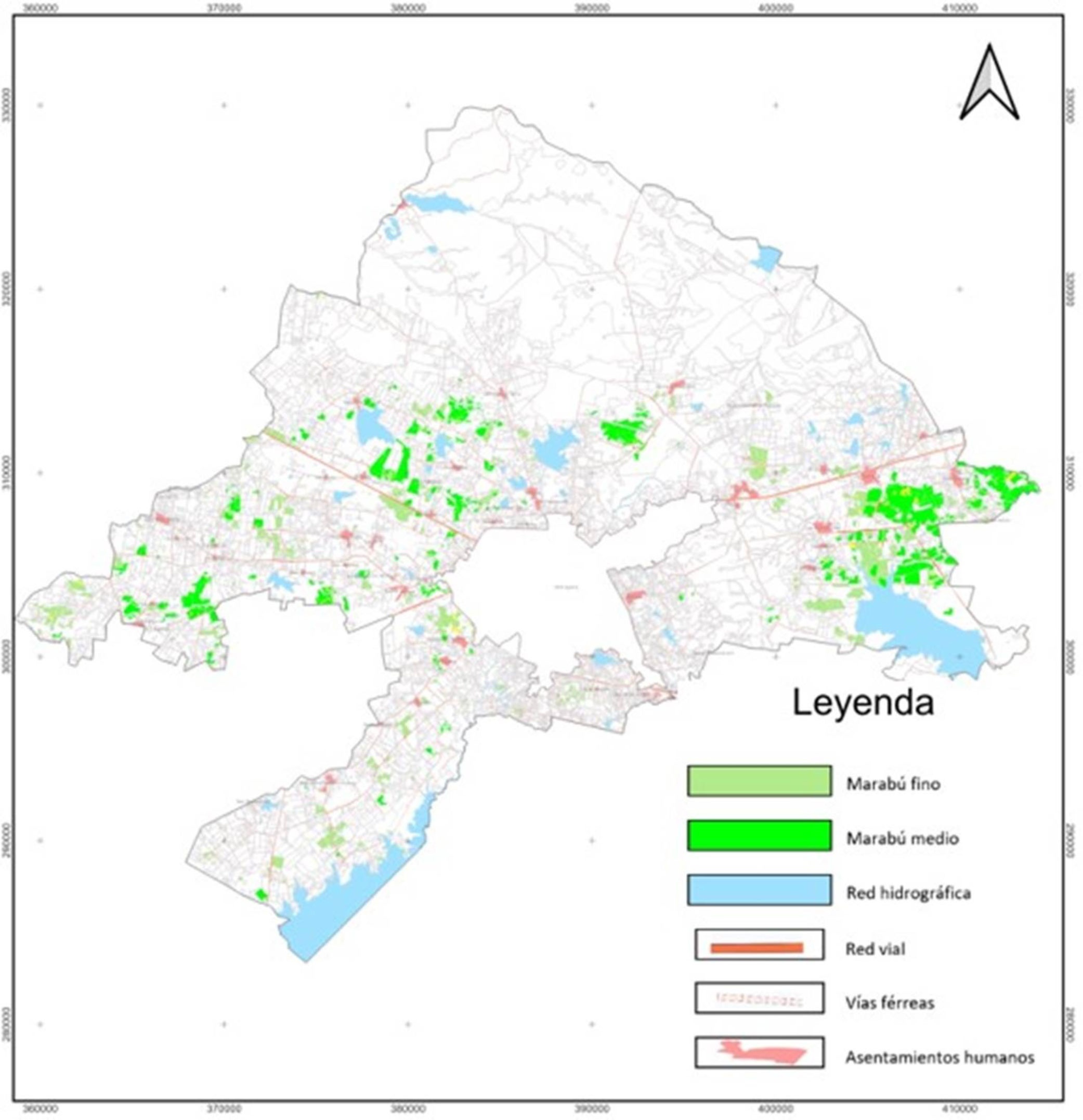
Geographic Information Systems (GIS) are used for the precise quantification of forest biomass to plan its sustainable energy use. This study aimed to provide a comprehensive tool for inventorying areas covered by Dichrostachys cinerea (marabou) in the municipality of Camagüey, facilitating the selection of cost-effective and environmentally responsible technologies and machinery systems. A comprehensive technological characterization was carried out using a standardized digital cartographic base and GIS with QGIS software. The methodology included delineating the effective marabou area using remote sensing, classifying it into diameter categories (fine and medium), and evaluating variables such as rockiness, slope, and land tenure. The results determined that the effective marabou area was 6310.45 hectares, dominated by the "medium" category (3517.41 ha), which was found mainly on relatively flat, relatively unrocked soils. The largest share of land ownership with this coverage corresponded to Credit and Service Cooperatives (CCS) and Agricultural Production Cooperatives (CPA), with an available biomass of 137,284.31 tons. It was concluded that the methodology employed guarantees a high-quality inventory and justifies the selection of semi-mechanized technologies for the energy use of biomass, and is also applicable to other forest inventories.
Downloads
Article Details

This work is licensed under a Creative Commons Attribution-NonCommercial 4.0 International License.
Those authors who have publications with this journal accept the following terms of the License Attribution-NonCommercial 4.0 International (CC BY-NC 4.0):
You are free to:
- Share — copy and redistribute the material in any medium or format
- Adapt — remix, transform, and build upon the material
The licensor cannot revoke these freedoms as long as you follow the license terms.
Under the following terms:
- Attribution — You must give appropriate credit, provide a link to the license, and indicate if changes were made. You may do so in any reasonable manner, but not in any way that suggests the licensor endorses you or your use.
- NonCommercial — You may not use the material for commercial purposes.
- No additional restrictions — You may not apply legal terms or technological measures that legally restrict others from doing anything the license permits.
The journal is not responsible for the opinions and concepts expressed in the works, they are the sole responsibility of the authors. The Editor, with the assistance of the Editorial Committee, reserves the right to suggest or request advisable or necessary modifications. They are accepted to publish original scientific papers, research results of interest that have not been published or sent to another journal for the same purpose.
The mention of trademarks of equipment, instruments or specific materials is for identification purposes, and there is no promotional commitment in relation to them, neither by the authors nor by the publisher.
How to Cite
References
Bravo, J. A., Vidal, A. M., Hernández, R. A., Valle, M., Padrón, R., & Paredes, L. (2015). Estimación de la biomasa aérea total verde con corteza de la vegetación de Dichrostachys cinerea (L.) Wr. Et Arn. Memorias de la Jornada Científica 45 Aniversario de la Fundación de la Estación de Guisa.
García, J. M., Vidal, A. M., Herrero, J. A., & Batista, E. (2012). Manual de procedimiento para el aprovechamiento de impacto reducido de los bosques de Cuba. Proyecto “Desarrollo del Sector Forestal en Cuba”. Dirección Forestal MINAG.
Herrero, J. A. (2003). Fajas forestales hidroreguladoras. Dirección Forestal MINAG.
MET. (2014a). Metodología para la Creación del Mapa Base de datos para el Catastro Rural e Implementación en el SIG (MET Nos. 30-14). Instituto de Planificación Física.
MET. (2014b). Indicaciones generales de redacción empleadas para la Mapificación Topográfica Digital (MET Nos. 40-60). Instituto de Planificación Física.
NC. (1988). Norma Cubana: 13-18:88. Mapa Catastral Especificaciones de Calidad.
SODePAZ. (2012). Aprovechamiento de la biomasa de marabú y otras especies energéticas como combustible en la generación de electricidad y recuperación ambiental en Camagüey (p. 36). SODePAZ.
Vidal, A., García, T., Bravo, J. A., Toirac, W., Hernández, A., Delgado, M., Álvarez, Y., Batista, F., Valle, M., & Padrón, R. (2019). Metodología para la caracterización tecnológica e inventario de las áreas cubiertas de marabú con fines energéticos (Segunda versión, p. 100).
Vidal, A., García, T. G., Méndez, M. D., Arguelles, W. T., & Carmenate, L. L. (2022). Caracterización tecnológica de las áreas cubiertas de marabú con fines energéticos mediante la aplicación de SIG. Revista Forestal Baracoa, 41, https://cu-id.com/0522/v41e07. https://forestbaracoa.edicionescervantes.com/index.php/fb/article/view/783